How Agerpoint Uses Smartphones and AI to Measure Plants at Scale
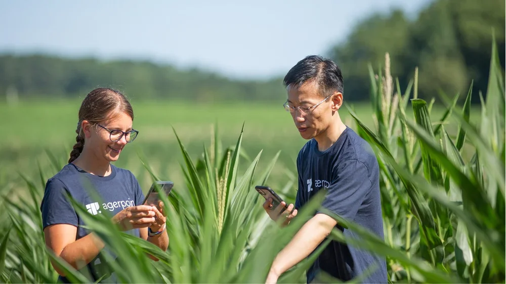
Image Credits: Agerpoint’s team
The Problem
Walk into a cocoa farm in West Africa and you'll immediately see why measuring plants is harder than it sounds. Trees don't line up neatly. Some stretch tall with spreading branches, others stay compact and uneven. Branches tangle across each other. Leaves hide the stems and fruit underneath. Sunlight filters through the canopy in constantly shifting patterns.
Farm managers still need basic answers: How many trees are actually producing? Which cocoa pods are ready to harvest? Are there early signs of disease starting somewhere? These seem like simple questions. Getting reliable answers across an entire farm is anything but simple.
The traditional approach means walking through fields tree by tree with tape measures and calipers, counting and recording everything by hand. It's slow work that requires trained agronomists or researchers, people who often aren't available in remote growing regions. So teams end up measuring maybe 50 trees and hoping those represent what's happening across the other 450 acres. Large sections of the farm stay unexamined.
This has always been part of how agricultural measurement works. When things go wrong, it becomes a serious limitation.
Why this matters
A few years ago, disease swept through cocoa-growing regions in West Africa. The disruption showed up fast in global markets: cocoa prices jumped 130%.
A major global food and beverage corporation faced an urgent problem. They didn't own these farms, but their entire business depended on cocoa from these exact regions now struggling with widespread crop loss. They needed answers: Where exactly is our cocoa coming from? Can we spot disease patterns before they spread everywhere? If we start sourcing from new regions, will the quality match what we need?
The situation exposed something familiar to anyone who's worked between research labs and actual farms. Measurement methods designed in controlled environments don't transfer easily to working landscapes. Field conditions are messy. Trees grow however they want. Lighting won't cooperate. Time and labor are always limited.
What blocks effective response isn't usually lack of expertise or good intentions. It's lack of data, specifically the ability to collect meaningful observations at the scale and speed that decisions actually require.
How Agerpoint approaches the problem
Agerpoint built their system around tools already in most people's pockets: smartphones.
About 87% of people globally now carry smartphones. These devices can capture images along with GPS coordinates, timestamps, and notes, all at once, in multiple languages. Agerpoint designed software that turns these everyday tools into precision measurement instruments.
Here's how it works in practice. A field worker walks around a cocoa tree, taking photos and short videos while an app guides them through the process. No agronomy degree needed. The app provides step-by-step instructions in whatever language the worker speaks. The whole capture takes a few minutes per tree.
Those images upload to Agerpoint's cloud platform, where algorithms stitch them together to build three-dimensional reconstructions, what Agerpoint calls digital twins, of the actual plants. Machine learning models then analyze these 3D models to do work that would otherwise take hours of manual counting:
Count every pod on the tree
Measure each pod's size to assess ripeness
Distinguish between canopy, trunk, and fruit
Detect visual signs of disease on leaves or pods
Calculate physical measurements like biomass
What the worker sees: a cocoa tree covered in brown pods. What the computer vision system sees: classified, color-coded objects. Green canopy, brown trunk, yellow pods. Each one counted and measured automatically.
For cocoa specifically, this solves a fundamental tedium problem. Imagine counting every single pod by hand, then measuring each one with calipers to check if it's ready to harvest. The 3D model does both, without anyone touching the tree.
The technical process works through something called structure-from-motion reconstruction. Multiple overlapping images captured from different angles enable the software to extract three-dimensional geometry. Machine learning models trained on thousands of labeled agricultural images then perform object detection, classification, and measurement tasks on these reconstructed plant models.
Layering Ground and Sky
Smartphones handle the close-up inspection. Understanding what's happening across entire fields requires a different view.
Agerpoint layers ground-level smartphone data with aerial imagery from drones or satellites. Each perspective serves a distinct purpose:
The aerial view shows patterns across whole farms. A drone flyover might reveal that one section has more reddish-brown canopy than surrounding areas, a potential early warning of stress or disease. Color classifications make this visible: green indicates healthy vegetation, pink or red signals something's off.
The ground view provides the diagnosis. Field workers can focus on those problem areas spotted from above, using smartphones to capture detailed data on specific trees. The 3D models and AI analysis then reveal what's actually wrong. Fungal disease, nutrient deficiency, pest damage, whatever it is.
Without this layered approach, sampling is essentially random. You walk the field, measure what you encounter, hope it's representative. With both perspectives working together, there's a systematic first pass showing where problems exist, then targeted investigation to understand why.
This addresses a fundamental sampling problem. Traditional methods rely on where it's convenient to collect data or where protocols arbitrarily specify. With aerial overview, sampling becomes strategically directed toward areas exhibiting noteworthy patterns.
The combination balances coverage and resolution. Aerial data provides extensive spatial coverage at lower detail. Ground captures provide high detail at specific locations. Together, they support both pattern identification and diagnostic investigation.
What this enables
The food corporation deployed Agerpoint's technology across several critical business needs. What emerged was a multi-functional data system serving different teams with overlapping requirements.
Disease Tracking and Early Intervention
Instead of only discovering disease after it's spread across entire farms, they could map exactly which trees showed symptoms, watch how it moved, and identify zones for potential treatment before farm-wide contamination occurred.
They integrated weather data, elevation maps, and wind patterns to model where disease would likely spread next. Similar to how epidemiologists traced COVID contacts, they could map disease instances geographically and predict transmission pathways.
This created intervention options that simply didn't exist before. If symptoms concentrated in one farm section, that area could potentially be isolated or treated to protect productive zones. Even imperfect early detection opened up choices between targeted response and reactive abandonment.
Remote Quality Verification
When exploring cocoa sourcing from new regions in Latin America, they could verify pod sizes and maturity without sending inspection teams for manual assessment. Quality standards could be checked before committing to procurement contracts.
This reduced both cost and risk in diversifying their supply chain. Rather than investing in new sourcing relationships based on limited samples or supplier claims, they could conduct systematic quality evaluation across representative tree populations remotely.
Harvest Optimization
Instead of sending workers across entire farms hoping to find ripe pods, operations could target specific trees where data showed harvest readiness. Labor efficiency improved. Waste from picking too early or too late decreased.
The 3D models provided harvest readiness scores based on pod size, color indicators visible in the imagery, and maturity patterns. Workers received maps showing which sections to prioritize rather than following predetermined routes.
Cross-Functional Data Utilization
The same physical measurements collected for counting pods also calculated carbon stocks for sustainability reports and verified locations for EU deforestation compliance. One data collection effort served multiple teams: agricultural operations, sustainability, procurement, regulatory compliance.
The EU deforestation regulation requires companies to track where commodities come from and verify no recent forest clearing occurred in those areas. The geospatial data already being collected for agricultural decisions directly addresses those compliance requirements. Different business units share the same datasets rather than duplicating field work.
For carbon accounting, the tree dimensional data, diameter at breast height, height, and canopy volume, needed for biomass calculations comes from the same 3D reconstructions used for pod counting. Agricultural teams and sustainability teams work from shared measurement outputs.
Where it falls short
Image-based measurement has real limits that affect what the system can detect.
Occlusion stays persistent. Dense canopies hide fruits and branches. Cameras can't see through leaves. What's hidden stays uncounted. This creates systematic undercounting in the densest canopy sections.
Environmental conditions matter constantly. Cloud cover, harsh shadows, glare, and time of day all affect image quality and what becomes detectable in the final analysis. A tree captured at noon under direct sun produces different detection results than the same tree captured at dawn under diffuse light.
Capture angle shapes results. Where someone stands while taking photos determines which parts of the plant are visible. If protocols aren't followed consistently, bias creeps in. Different workers following slightly different walking paths around trees introduce measurement variability.
Resolution limits set boundaries. Smartphone camera quality determines the smallest features that can be detected and measured. Early disease symptoms appearing as small discolorations may not be visible at typical capture resolutions.
Model accuracy depends entirely on training data. Machine learning performs only as well as the examples it learned from. Disease detection accuracy, for instance, requires having sufficient images of how diseases actually appear across different cocoa varieties, growth stages, and environmental conditions. Models trained predominantly on one variety may perform poorly on others.
The digital twins are useful representations, not perfect replicas. They simplify biological complexity into forms that algorithms can analyze. A 3D model captures enough detail for measurement and decision-making, but it's still a computational approximation of physical reality, not the plant itself.
The technology makes observation and measurement feasible at scales that weren't practical before. It doesn't eliminate uncertainty. It makes uncertainty visible enough and quantified enough to actually support decisions.
Applications Beyond Cocoa
The same measurement challenge shows up across different contexts where traditional methods hit scalability limits. Agerpoint has deployed variations of this approach in several agricultural and land management settings.
Viticulture
Counting grape clusters to estimate yield per vine. Dense foliage creates the same hiding problems as tree crops. The 3D reconstruction approach counts clusters that manual tallies would miss, particularly those deep inside the canopy or on the vine's interior side.
Agroforestry Systems
A carbon project in East Africa needed to track fruit trees for two different purposes: agricultural productivity, so farmers earn income, and carbon sequestration for climate credits. The same tree measurements served both needs. Dimensional data collected for counting fruit automatically provided the diameter, height, and canopy volume needed for biomass calculations. One workflow, multiple uses, spreading cost across different program objectives.
Row Crops
Analyzing corn, soybeans, and similar field crops. Stand counts to verify planting density, uniformity assessment to identify gaps or problem zones, early stress detection before visible symptoms become severe.
Urban Forestry
City parks departments face similar constraints: thousands of trees, limited staff, need for consistent monitoring over years. The technology supports tree inventory, creating initial asset databases, growth tracking by comparing 3D models captured at different time points, and identifying which species thrive in which urban microclimates based on performance patterns.
Reforestation Sites
Tracking planted tree survival and growth without destructive sampling. Creating 3D representations of the same trees over time shows growth patterns and helps verify restoration outcomes. Survival rates, height growth, canopy development, all become observable through repeated non-destructive capture.
Biodiversity Monitoring
While specific metrics vary by ecosystem, the underlying capability applies broadly: systematically documenting what's present, where it occurs, and how it changes over time through structured visual records. During the session, questions arose about biodiversity applications. The response highlighted that biodiversity measurement depends heavily on local ecological context, but the fundamental workflow of guided data capture, multi-language support, GPS-tagged observations, and citizen science activation works across different monitoring needs.
The technology isn't crop-specific or context-specific. It addresses a general problem: turning visual complexity into structured data you can actually analyze and act on.
Operational Deployment
Agerpoint works primarily business-to-business with organizations managing land at scale. The purchasing organization and the actual users are often different groups.
A food corporation might purchase the technology for their supply chain. A conservation organization might use it across restoration projects. A city government might deploy it for park management. But the daily users are usually farmers, field workers, or local community members, not people with formal technical training.
The smartphone interface, multi-language support, and guided step-by-step workflows make this work. The app accommodates the reality of who's actually out there collecting data in field locations.
Implementation typically starts with technology evaluation. Agerpoint tests their approach against whatever manual methods are currently being used in specific client contexts. This establishes whether the tools address particular measurement needs and how data collection programs should be structured. Not every context benefits equally. Evaluation determines applicability and design requirements before broader deployment.
The business model recognizes that the buyer, perhaps a sustainability director or supply chain manager, has different needs and perspectives than the user, perhaps a smallholder farmer or field technician. Success requires serving both: demonstrating value to decision-makers while ensuring usability for operators.
The Broader Pattern
What Agerpoint does reflects a bigger change in how measurement works for anything involving plants and land.
Measurement is moving away from purely physical inspection toward interpretation of digitally reconstructed visual representations. Images only become useful for measurement when computational processes can extract structure from visual variability, separating signal from noise, plant from background, healthy tissue from diseased.
But having the technology isn't enough. Workflows have to function in real operational conditions:
Spotty internet that comes and goes, so data syncs when connection returns rather than requiring constant connectivity
Field locations where workers speak languages other than English, requiring localized interfaces
Production farms that are nothing like controlled research plots, with all the irregularity that entails
Data collectors who may never have taken a biology class, who need clear guidance rather than assumed expertise
Many agricultural technologies fail exactly here, at the gap between research precision and field practicality. Agerpoint's design explicitly targets this gap. The tools work where and how they'll actually be deployed, not where engineers wish they'd be deployed.
This comes from direct experience. Agerpoint's team includes people who worked on carbon projects in East Africa, seeing firsthand how climate change hits equatorial agricultural regions and what data requirements real land-use programs face versus what gets assumed during planning. The framing stays consistent: technology serves as a means to solve problems, not an end in itself.
Outcomes and Implications
When disease disrupted West African cocoa production, the core problem wasn't lack of concern or insufficient resources. Data wasn't moving from farms to decision-makers fast enough or at sufficient scale to enable response.
Smartphones and AI didn't cure plant disease. They made disease visible, trackable, and quantifiable through methods that could actually reach across dispersed growing regions. That visibility created options for action: early intervention, targeted treatments, diversified sourcing, verified quality.
For the food corporation, this meant shifting from reactive crisis management to proactive monitoring capabilities. Disease surveillance became continuous instead of episodic. Quality checks became systematic instead of sample-based. Supply chain transparency increased. Different business functions started working from shared datasets instead of each running separate collection efforts.
The practical impact shows up in operational changes: labor deployed more efficiently based on where data indicates need rather than predetermined schedules, procurement decisions informed by actual quality data rather than supplier assurances, sustainability reporting drawing from the same measurements used for farm management rather than requiring separate data collection.
The pattern reaches beyond cocoa and beyond agriculture. Anywhere biological variability intersects with operational decisions, farming, forestry, restoration, urban greening, conservation, being able to convert observation into structured, repeatable data at scale changes what becomes manageable.
The real achievement isn't the technology for its own sake. It's making precision measurement practical in places where cost, expertise requirements, or logistics previously made it impossible.
Key Insights
The Core Innovation: Smartphones become measurement instruments through software that converts imagery into structured 3D plant models analyzed by machine learning
The Operational Strategy: Ground-level detail combined with aerial pattern recognition creates both diagnostic capability and spatial context
The Business Model: Single data collection workflows serve multiple organizational functions, spreading costs across agricultural, sustainability, and compliance needs
The Technical Constraint: Detection accuracy depends on image quality, environmental conditions during capture, and machine learning model training comprehensiveness
The Scalability Factor: Non-expert users can collect expert-grade measurements through guided workflows and automated analysis
Case Classification
Measurement · Modeling · Computer Vision · Digital Reconstruction
Image-derived plant-level observations
Perennial Crop Systems · Agricultural Supply Chains