How Agerpoint helped a global food corporation get ahead of a cocoa crisis, and what it took to make plant-level data actually work in the field
Overview
Cocoa is in everything. Chocolate bars, confectionery, flavourings, it's a commodity so embedded in food supply chains that most companies take it for granted. Until a few years ago, disease swept through cocoa farms across West Africa and prices jumped 130% almost overnight.
For one major global food and beverage corporation, the crisis exposed some oversight. They had built an entire business on cocoa from these regions, but they had limited visibility into what was actually happening on the farms. The supply chain wasn't traceable all the way to specific cacao farms. They couldn't track whether their farms were at risk of disease. They had no reliable way to check whether cocoa from a new region would meet their quality standards.
The data existed, in theory. It just couldn't be collected fast enough, or at the right scale, to be useful.
This is the problem Agerpoint set out to solve: How do you get precise, plant-level observations from remote farms to the people who need to act on them, without it taking months and costing a fortune?
Why This Is Hard
Before any technology enters the picture, it helps to understand what agricultural measurement actually looks like on the ground.
A specialist visits the farm and completes a concentrated round of data collection. They walk rows of cocoa trees with a tape measure and calipers, count pods by hand, measure each one individually to check ripeness, and look closely at leaves for early signs of disease. By the time the report reaches decision-makers who can act on it, days or weeks have often passed.
Some growers have even less visibility. In many of the regions where cocoa grows, specialist agronomists aren't available locally. In these cases, field workers may measure a small sample of trees in an effort to predict what's happening everywhere else. Entire sections of a farm may go unexamined. Problems are at risk of staying invisible until they're too big to ignore.
For a corporation trying to manage supply risk, this isn't just inconvenient. It means operating with significant knowledge gaps. Buyers often learn of a disease outbreak only after prices have already spiked, not when the first trees start showing symptoms.
One Approach in Practice
Agerpoint's first question was: What do people in remote growing regions already have access to? The answer, for the vast majority of people globally, is a smartphone.
Rather than building new hardware or training new specialists, Agerpoint built software that turns an ordinary smartphone into a precision field inspection tool. A local field worker walks around a cocoa tree, taking photos and short video clips while the app guides them through each step. The instructions are simple enough that no agronomy background is needed, and the app works in multiple languages so it can be used by workers across different regions. The whole capture takes a few minutes.
Where previously the corporation may have needed to fly in a researcher to measure a tree by hand, now a local worker with a phone can do it, consistently, repeatedly, and across far more trees than any visiting expert could manage.
That data is uploaded to Agerpoint's cloud platform, where it is processed and analyzed. Agerpoint generates a high-quality, spatially accurate digital twin that is analyzed using machine learning to automate traditionally manual tasks: counting pods, estimating size, evaluating harvest readiness, and making note of potential disease instances.
The contrast is stark. Before, field inspectors would manually measure and evaluate cacao trees for hours. Now, the model does it automatically, across dozens of trees at once, producing results in a fraction of the time.
But knowing what's happening on individual trees still isn't enough. To manage a farm, or a supply chain, you need to understand patterns across the whole landscape.
This is where aerial imagery comes in. Agerpoint layers the ground-level smartphone data with images from drones or satellites. The aerial view acts as an early warning system. When one section of a farm starts showing stress, it shows up as a color shift in the imagery: for example, green for a healthy canopy, red or pink for something that needs attention. Instead of sending workers to walk the entire farm hoping to stumble across a problem, teams can now see exactly where to look before anyone steps into the field.
The combination of full-field analytics and mobile point inspections is changing what is possible across many business units in the agricultural value chain. For farm managers, using accessible tools to monitor tree and crop health in real time can allow for early intervention at specific sites to mitigate major production losses. Layering in supplementary datasets such as topography and weather data helps model where diseases are likely to spread, creating an early warning system that gives time to respond. For quality managers, having a clearer signal of harvest readiness and volumes can allow for improved negotiations and sourcing diversification before a local or regional ecological crises. For compliance teams, the same tools and teams used to support agronomy and procurement can be used to gather sustainability and regulatory data points without commissioning their own field teams or conducting separate field visits.
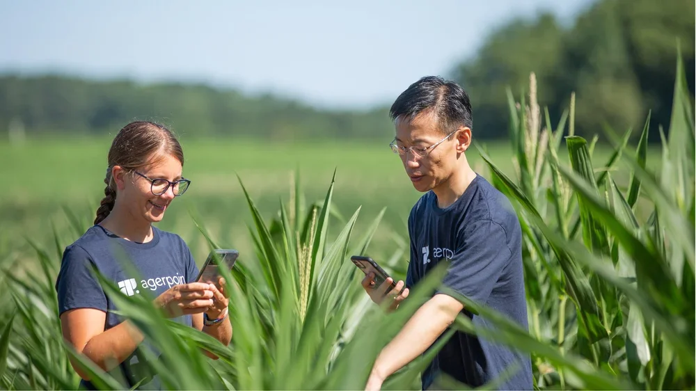
Image Credits: Agerpoint
What This Enables, and Where It Requires Oversight
What changes:
The corporation went from reacting to crises to maintaining a more proactive, continuous picture of what was happening across their supply chain. Decisions that used to be made on limited information, when to harvest, where disease risk was building, whether a new sourcing region was viable, could now be made on robust data.
The other shift was internal. Teams that had often operated in silos, each running their own data collection, were able to work from shared information. That has real cost implications, but it also changes how a company responds when something goes wrong. Everyone is looking at the same picture.
Where it requires oversight:
The quality of what comes out depends on the quality of what goes in. If field workers don't follow the capture process consistently, results become harder to compare across trees and sites. Getting that consistency right takes investment in training and workflow design, it doesn't happen automatically.
The machine learning models that detect disease are trained on existing images, which means they perform best in conditions similar to where that training data came from. A model built on data from one cocoa variety or one region may require additional training for a different variety or new disease. The system must be tested and validated in each new context.
Biodiversity contexts require expert oversight. Agerpoint's tools can support structured data collection by local communities, with GPS tagging and multi-language support. But biodiversity measurement depends heavily on local ecological knowledge, what to measure, what counts as healthy, what species matter in a given landscape.
What Others Can Take From This
Visibility has to come before strategy. The corporation's challenge wasn't that they lacked a sustainability strategy or supply chain ambitions. It was that they had limited visibility into what was actually happening on the farms they depended on. Any organization seeking to manage nature risk needs to start with the question: What does our data tell us, and where are we operating with limited information?
The tool is only as good as the workflow around it. Agerpoint's technology works in practice because it was designed for the conditions that actually exist in the field: limited connectivity, workers with different languages and skill levels, farms that are nothing like a controlled research environment. A tool that works perfectly in a lab or a pilot but breaks down at the point of real deployment is not a solution. Test for field conditions, not ideal conditions.
Look from above before you send anyone in. Using aerial imagery to identify where problems might be, before directing ground teams to investigate, makes field data collection far more effective. Without that first pass, sampling is random. Random sampling across hundreds of acres will result in blind spots.
One data collection effort should serve more than one team. The separation between agricultural data, sustainability data, and compliance data is often an organizational habit rather than a technical necessity. If the right information is captured once, it can flow to procurement, sustainability, and compliance simultaneously. That requires deciding upfront what everyone needs, not retrofitting it later.
The buyer and the user are rarely the same person. The corporation bought the technology. The field workers used it. Both groups had to be served for the system to work. Any organization deploying nature measurement tools needs to think carefully about usability at the point of collection, not just value at the point of reporting.
Case Classification:
Measurement · Modeling · Computer Vision · Digital Reconstruction Image-derived plant-level observations · Perennial Crop Systems · Agricultural Supply Chains